Letterbox


Our reliable walkers go the extra mile to get your information into people’s hands – whether that means tracking down the strata manager of a locked building or taking note of the addresses without a letterbox.
We capture all this local detail in our distribution database – which helps us to constantly improve our service.
We can distribute to small areas of less than 50 to extensive areas covering multiple local government areas with quantities ranging from 20,000 to more than 200,000.
On request, we can also provide coverage in the central and south coast regions and into the western areas of Sydney which often include semi-rural and industrial precincts.
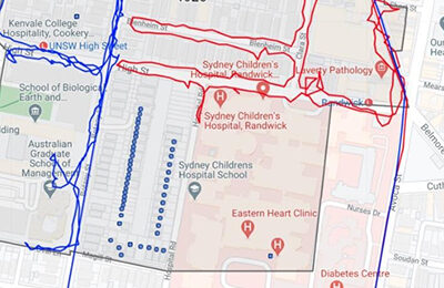
All distributions are monitored using ManageMy Post, GPS tracking software. Developed specifically for letterbox distributors, MMP lets you create custom maps of your distribution area and see exactly where and when our walkers have delivered.
Want to know more about ManageMy Post?
What details do I need to provide so you can get me a distribution quote?
- Map or a description of the distribution area
- Tentative date for distribution
- Target for the distribution (Residents Only, Business Only or Business and Residential)
- Priority Area (if you have one)
- Return of stock if you would like to have leftovers couriered
Can I use your software to map my distribution area and estimate the number of letterboxes?
Yes! We can give you your own login to our ManageMy Post software which will allow you to create your own maps, automatically estimate the number of letterboxes and view completed jobs with GPS tracks.
Is there a minimum number of items that you’ll distribute?
No, we can do one property or entire postcodes.
How long will it take to distribute my newsletter?
Depends on the size of the distribution zone. Smaller jobs are usually completed in one day, with larger distributions generally ranging between 2 – 3 days.
Do you deliver to secure buildings?
In the event that the letterboxes are inside a locked or secure building:
- The distributor will try to find the contact information for the Building Manager or Strata management
- They will contact the building manger to try and gain access to the mail room/ building
- If we are unsuccessful (after multiple attempts), we will note down the undelivered addresses in an Exceptions Report.
- Once we provide you with the report, you may ask us to re-attempt, and if unsuccessful affix a notification to the outside of the building or post the letters to the undeliverable address via Australia Post.
How will you confirm my item has been delivered?
We will send you a ManageMy Post map of your distribution area with the GPS tracks of each distributor overlaid so you can see exactly where they walked and when.
What are the blue dots on my distribution map?
Our tracking software uses the Federal Government's Geocoded National Address file (GNAF) as a data source. In most instances the GPS point for each property is set in the middle of the property or nearer the street frontage. We geofence these properties, and when a walker walks within 2m of the property it lets us know by checking off the blue dot. When the GPS point for that property is set back further into the lot, the geofence is set back further and so the blue dot isn't checked.
This can include instances where:
- The property is set back well from the street (like a battle-axe property arrangement) and are likely to have a letterbox on the street
- There is a GPS point for a park, or beach
- The geocode for that property is not set to the middle of the property, but at the far end
In all the above cases, these blue dots are either not delivery points or the letterbox was on the street.
Where do you get your distributors?
Almost all of our distributors are tertiary students, and a portion of these are doing a communications related degree at Uni (which is really useful for walking into businesses and handing things over or doing station handouts).
What areas do you distribute to?
We operate predominately in the Sydney Metro area, but we’re happy to speak to you about areas outside Sydney.


